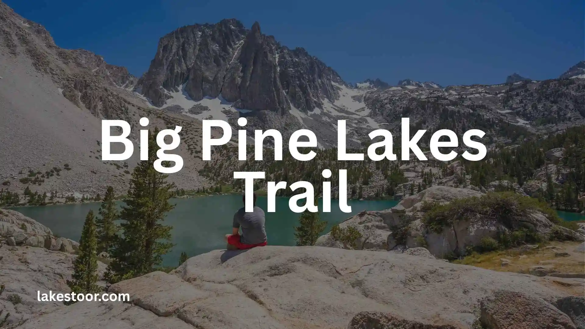
The Big Pine Lakes Trail is one of the most spectacular hiking routes in California’s Eastern Sierra. Located in the Inyo National Forest near Big Pine, the trail follows the North Fork of Big Pine Creek into the John Muir Wilderness, passing waterfalls, pine forests, alpine lakes, dramatic granite peaks, and the famous turquoise waters beneath Temple Crag.
For many hikers, Second Lake and Third Lake are the main rewards. Third Lake is especially memorable because it is fed directly by the Palisade Glacier, giving its water a distinctive milky turquoise appearance from glacial sediment. The route also provides access toward the Palisade Glacier itself.
This guide explains the trail distance, elevation, difficulty, route, parking, permits, camping, best time to visit, water, safety, and what to expect on the hike so you can plan your trip with fewer surprises.
Big Pine Lakes Trail at a Glance
| Trail detail | Information |
| Location | Big Pine, California |
| Forest | Inyo National Forest |
| Wilderness | John Muir Wilderness |
| Trail | Big Pine Creek North Fork |
| Main destination | Big Pine Lakes |
| Famous viewpoint | Temple Crag |
| Glacier | Palisade Glacier |
| Difficulty | Moderate to difficult, depending on destination and conditions |
| Day hiking | No wilderness permit required |
| Overnight backpacking | Wilderness permit required |
| Elevation | High-elevation Sierra Nevada terrain |
| Main season | Typically summer into fall, depending on snow and conditions |
| Water | Big Pine Creek and lakes; treat before drinking |
| Camping | Permitted in the wilderness with required permit and regulations |
Exact mileage and elevation gain vary depending on whether you stop at Second Lake, continue to Third Lake, visit higher lakes, or extend the trip toward the Palisade Glacier. One commonly mapped North Fork route is about 7.5 miles point-to-point with roughly 3,538 feet of gain, while popular out-and-back itineraries to the lakes are longer.
Important: Do not plan your trip around a single mileage number without identifying your turnaround point. “Big Pine Lakes Trail” can refer to several different destinations along the North Fork.
Where Is Big Pine Lakes Trail?
The Big Pine Lakes Trail is near the town of Big Pine, California, on the eastern side of the Sierra Nevada.
From U.S. Highway 395, hikers drive west through Big Pine and continue up Big Pine Canyon toward the trailhead. The Forest Service describes the drive as approximately 10 miles from Highway 395 to the end of the road. Day-use parking is near the road’s end, while overnight parking is approximately half a mile below the end of the road.
The approach itself is part of the adventure. As you leave the desert-like landscape around Big Pine and climb into the canyon, the environment changes to pine forest, creekside vegetation, waterfalls, and eventually high alpine terrain.
Big Pine Lakes Trailhead and Parking
The trailhead area can be confusing if you have not researched it beforehand because day-use and overnight parking are not necessarily the same.
The Forest Service states that:
- Day-use parking is at the end of the road.
- Overnight parking is about 0.5 mile below the road’s end.
- The approach follows Big Pine Canyon Road from Big Pine.
Before your trip, check current road and trail conditions. Mountain access can change because of snow, storms, road maintenance, wildfire restrictions, or other seasonal issues.
If you are camping overnight, allow additional time for parking and walking to the trailhead.
How Long Is the Big Pine Lakes Trail?
There is no single distance that applies to every Big Pine Lakes hike.
The distance depends on your objective:
- Second Lake: A popular turnaround or overnight destination.
- Third Lake: A longer outing with some of the most recognizable scenery.
- Fourth through Seventh Lakes: More demanding exploration beyond the classic lower-lake route.
- Palisade Glacier: A significantly more challenging extension beyond Third Lake.
One mapped North Fork route lists 7.5 miles and 3,538 feet of elevation gain, while another commonly used backpacking itinerary lists approximately 9.6 miles round trip to Second Lake from overnight parking.
This difference illustrates why hikers should check the exact route and destination rather than relying on a generic “Big Pine Lakes mileage” figure.
How Much Elevation Gain Does Big Pine Lakes Have?
The trail climbs substantially from the Big Pine Creek area into the alpine basin.
A mapped North Fork route records approximately 3,538 feet of ascent, reaching an elevation of about 11,240 feet at its high point on that mapped section.
Other itineraries that stop at the lower lakes report different elevation gains because they use different starting points and turnaround locations.
The important point is that this is a high-altitude mountain hike. Distance alone does not tell you how difficult the trail will feel.
Is Big Pine Lakes Trail Hard?
For an experienced hiker, the classic route to the lower lakes is achievable with proper preparation. However, it should not be treated as an easy lakeside walk.
The difficulty comes from several factors:
- Significant elevation gain
- High altitude
- Long distance
- Uneven mountain terrain
- Potential snow and ice
- Rapid weather changes
- Limited cell service
- More demanding conditions beyond the main lakes
The route becomes substantially more serious if you continue toward the Palisade Glacier. The Forest Service notes that the final portion toward the glacier involves boulder hopping and an obscure trail, and warns that the upper glacier should be avoided unless you are experienced with ice and snow travel.
Is Big Pine Lakes Good for Beginners?
A reasonably fit beginner who has experience with long hikes and understands mountain safety may be able to handle the lower route under good conditions.
However, this is not the trail I would recommend as a first-ever high-altitude hike.
Beginners should start with shorter mountain hikes, learn how their bodies respond to elevation, and avoid extending the route simply because they have reached one lake successfully.
Big Pine Lakes Trail Route
The North Fork route has several distinct sections, and understanding them makes the hike easier to visualize.
1. Big Pine Creek Trailhead
The hike begins near Big Pine Creek in the upper canyon.
The early trail passes through vegetation including sagebrush, manzanita, and Jeffrey pine before climbing toward the creek and waterfalls.
This lower section can feel very different from the alpine scenery you are expecting. Don’t worry—the dramatic lake views come later.
2. Waterfalls and Big Pine Creek
As you climb, the trail reaches waterfalls and follows Big Pine Creek deeper into the canyon.
The sound of running water and the surrounding forest provide a pleasant contrast to the more exposed upper sections.
3. Lon Chaney Cabin
A distinctive historic feature along the route is an old cabin associated with actor Lon Chaney.
The Forest Service specifically mentions the cabin along the North Fork route.
It is an easy detail to miss if you are focused only on reaching the lakes, so keep an eye out as you move through the forest.
4. First Lake
Eventually, the trail reaches the Big Pine Lakes basin.
First Lake is the beginning of the classic alpine-lake scenery and gives hikers their first major taste of the high-country environment.
5. Second Lake
Second Lake is one of the most popular destinations on the route.
It offers impressive views of Temple Crag and is a common destination for backpackers. Some hikers choose to make Second Lake their base camp before exploring higher parts of the basin.
If you are planning your first overnight Big Pine Lakes trip, Second Lake can be a practical objective, subject to current camping regulations and permit conditions.
6. Third Lake
Third Lake is arguably the signature destination of Big Pine Lakes.
The lake receives water directly from the Palisade Glacier. Fine glacial sediment in the water creates the characteristic milky turquoise color that makes photographs from this area so recognizable.
Above the lake stands the imposing Temple Crag, creating one of the most dramatic mountain-and-lake views in the Eastern Sierra.
7. Higher Lakes
The North Fork continues beyond the first three lakes toward additional lakes and higher terrain.
This section requires more route-finding and mountain judgment than simply hiking to the classic lower lakes.
If conditions are snowy, the route can become much harder to follow. A recent 2026 hiker report, for example, described significant snow and difficulty following the trail on higher sections during late June.
Treat such reports as anecdotal rather than a substitute for current official conditions.
Also Check This Post: Cascade Lakes Scenic Byway: Complete Guide to the Route, Lakes, Stops, Hiking, Camping & Road Trip Tips
First Lake vs. Second Lake vs. Third Lake
If you are wondering which lake is best, the answer depends on what you want from your hike.
First Lake
Best for:
- A shorter objective
- Seeing the beginning of the alpine basin
- Hikers who need an easier turnaround
Second Lake
Best for:
- Backpacking
- Temple Crag views
- Sunrise and sunset photography
- A balance between effort and scenery
Third Lake
Best for:
- The classic turquoise-water experience
- Glacier scenery
- Temple Crag photography
- Hikers who want to go farther into the basin
If your goal is the iconic Big Pine Lakes experience, Third Lake is one of the strongest objectives, but Second Lake already provides spectacular scenery.
Temple Crag: The Iconic Big Pine Lakes Landmark
Temple Crag is one of the defining features of the Big Pine Lakes landscape.
Its dark, sharply rising granite walls contrast with the colorful alpine lakes below. The result is a landscape that looks almost unreal, particularly when the water is calm enough to reflect the surrounding peaks.
You do not need to climb Temple Crag to enjoy it. For hikers, the lakes provide exceptional views of the formation from below.
Palisade Glacier
The Palisade Glacier is another major attraction.
The Forest Service describes it as the largest glacier in the Sierra Nevada. The trail toward the glacier branches about half a mile above Third Lake and continues through grassy benches and boulder terrain toward Sam Mack Meadow.
The final section toward the glacier is not simply a continuation of an easy hiking trail.
The Forest Service specifically warns that the last portion is difficult to follow and involves boulder hopping. It also advises inexperienced hikers to avoid the upper glacier terrain.
For most visitors, the lakes themselves are enough. Do not attempt glacier travel without the appropriate skills, equipment, experience, and conditions.
Big Pine Lakes Permit Requirements
Permit rules are one of the most important parts of planning this trip.
For overnight wilderness trips, Inyo National Forest requires wilderness permits year-round for the John Muir Wilderness and other listed wilderness areas. Day hiking does not require an overnight wilderness permit.
The current Recreation.gov system states that:
- Reservations open online daily at 7 a.m. Pacific Time.
- 60% of the quota is released six months in advance.
- The remaining 40% is released two weeks before the entry date.
- A $6 non-refundable reservation fee applies.
- A recreation fee is also charged per person for applicable Inyo National Forest wilderness permits.
Because permit rules, quotas, and availability can change, verify the current requirements on Recreation.gov before your trip.
Big Pine Lakes Camping
Camping is one of the best ways to experience the area.
Instead of hiking to the lakes, taking a few photographs, and immediately descending, an overnight trip lets you enjoy:
- Sunset over the mountains
- Sunrise at the lakes
- Night skies
- Longer photography sessions
- Exploration of multiple lakes
- A more relaxed hiking pace
However, wilderness camping comes with additional responsibilities.
You must have the appropriate permit, follow current campsite restrictions, store food properly, protect vegetation, and pack out your waste and trash.
The Inyo National Forest advises keeping camps at least 100 feet from lakes, streams, and trails and avoiding camping on vegetation.
Can You Camp at Second Lake?
Second Lake is a popular backpacking destination, but you should not simply arrive and select any spot you want.
Your wilderness permit and current regulations determine where and how you can camp. Always check the applicable permit information and camping rules before your trip.
Big Pine Lakes Day Hike vs. Backpacking
Day Hiking
A day hike makes sense if:
- You are experienced with long hikes.
- You start early.
- Weather conditions are favorable.
- You have enough daylight.
- You are comfortable with the elevation.
- You have a clear turnaround plan.
The biggest advantage is that you do not need overnight camping equipment.
The disadvantage is that you have less time to enjoy the lakes and must complete the descent the same day.
Backpacking
Backpacking is a better option if you want to:
- Photograph sunrise and sunset
- Explore multiple lakes
- Take your time
- Reduce the pressure of a long same-day return
- Spend a night in the Sierra
The tradeoff is the heavier pack, permit requirement, food storage, and additional preparation.
For a first visit, a well-planned overnight trip can provide a much more relaxed experience.
Best Time to Hike Big Pine Lakes Trail
The best time depends on snow conditions, road access, weather, and your experience.
Summer
Summer is generally the most popular period.
Advantages include:
- Longer daylight
- Better access to the high country
- More opportunities for snow-free hiking
- Alpine lakes and wildflowers
- Warmer daytime conditions
However, summer also brings more visitors, stronger sun, and the possibility of afternoon thunderstorms.
Early Fall
Early fall can be excellent.
You may experience:
- Cooler temperatures
- Fewer crowds
- Clear mountain views
- Autumn color in lower elevations
- More comfortable hiking temperatures
The days are shorter, however, and winter weather can begin returning to the high country.
Spring and Early Summer
This period can be much more complicated.
Snow and ice may remain on the upper trail, and route-finding can become difficult.
Do not assume that a calendar date guarantees summer conditions. A 2026 hiker report from late June described substantial snow on higher sections and difficulty following the route.
Always check current conditions before leaving.
Big Pine Lakes Weather
Mountain weather can change rapidly.
The Forest Service specifically warns hikers that Sierra Nevada weather conditions can change quickly and recommends carrying adequate clothing for anticipated changes.
Even if the forecast looks warm in Big Pine, conditions at 10,000 feet or higher can be dramatically different.
Pack layers rather than relying on a single weather forecast.
Be prepared for:
- Cold temperatures
- Wind
- Rain
- Thunderstorms
- Snow
- Sudden temperature changes
- Strong sun
If thunderstorms develop, reconsider exposed ridges and high-elevation objectives.
Altitude and Acclimatization
Altitude is one of the most overlooked challenges of Big Pine Lakes.
The trail climbs from the canyon into high Sierra terrain, and your body may react differently than it does at lower elevations.
Possible symptoms of altitude illness can include:
- Headache
- Unusual fatigue
- Dizziness
- Nausea
- Reduced appetite
- Difficulty sleeping
- Shortness of breath beyond what you would normally expect from exertion
The Inyo National Forest specifically advises visitors to learn the symptoms of altitude sickness and to plan for self-sufficiency.
If symptoms become severe or worsen, descending to a lower elevation is more important than reaching the lake.
Water on Big Pine Lakes Trail
Water is available from Big Pine Creek and other natural sources, but do not assume it is safe to drink untreated.
The Forest Service recommends boiling water or using an appropriate filtering system because of waterborne pathogens such as Giardia.
A practical approach is to:
- Carry enough water for the next reliable source.
- Use a quality filter or appropriate purification method.
- Keep untreated and treated water separate.
- Avoid drinking directly from lakes or streams.
Remember that natural-looking mountain water is not automatically clean drinking water.
Also Check This Post: Land Between the Lakes National Recreation Area: Complete 2026 Visitor Guide
What to Pack for Big Pine Lakes Trail
Your gear should match your route and season.
Essential Day-Hike Gear
- Plenty of drinking water
- Water filter or purification method
- High-energy food
- Offline map
- Navigation device
- Fully charged phone
- Headlamp
- First-aid kit
- Hiking shoes or boots
- Trekking poles
- Sun hat
- Sunglasses
- Sunscreen
- Warm layers
- Rain or wind shell
- Emergency communication device if available
Additional Backpacking Gear
For an overnight trip, also bring:
- Backpack
- Tent or appropriate shelter
- Sleeping bag
- Sleeping pad
- Backpacking stove if permitted
- Food
- Bear-resistant food-storage equipment where required
- Water-treatment system
- Extra clothing
- Wilderness permit
- Map and backup navigation method
Do not overload yourself unnecessarily, but do not leave essential safety equipment behind to save weight.
Bear Safety and Food Storage
The Sierra Nevada is bear country, so food storage matters.
Inyo National Forest requires appropriate food and scented-item storage in areas with bear conflicts and provides specific food-storage requirements for wilderness users.
Never:
- Leave food unattended
- Store food inside your tent
- Leave scented items lying around camp
- Leave trash behind
- Assume a backpack is sufficient bear protection
Check the current regulations for your specific area before departure.
Cell Service and Navigation
Do not depend on your phone having reliable service.
The Inyo National Forest specifically warns visitors that most of the forest has no cell service and recommends downloading maps and emergency information before starting the trip.
Before leaving the trailhead:
- Download an offline map.
- Know your planned route.
- Save emergency information.
- Carry a backup navigation method.
- Tell someone your itinerary.
- Know your planned turnaround time.
This becomes especially important if you continue beyond the classic lower lakes.
Big Pine Lakes Trail Safety
Start Early
An early start provides more daylight, cooler temperatures, and additional time if something goes wrong.
Know Your Turnaround Point
Do not decide your turnaround point only after you become tired.
Choose a reasonable destination before starting and adjust it based on weather and trail conditions.
Watch for Afternoon Storms
Thunderstorms can develop rapidly in the Sierra Nevada.
If the forecast calls for storms, plan conservatively.
Don’t Follow Unsafe Snow Tracks
Tracks left by another hiker do not mean the route is safe.
Snow bridges, icy slopes, and hidden hazards can change daily.
Be Careful Around Waterfalls
Wet rocks near waterfalls can be extremely slippery.
Stay back from edges and avoid climbing around rushing water simply for a photograph.
Horses and Pack Stock
Pack stock may use trails in the Big Pine area.
The Forest Service reminds hikers that stock have the right of way. If horses or pack animals approach, move safely off the trail and remain quiet until they have passed.
This is particularly important on narrow sections where there may not be much room to pass.
Fishing at Big Pine Lakes
Fishing is another activity available in the Big Pine Canyon area.
The Forest Service notes that rainbow trout can be found in many of the lakes, while golden trout occur in higher lakes.
If fishing is part of your trip, check current California fishing regulations, licensing requirements, and local restrictions before you go.
Photography Tips for Big Pine Lakes
Big Pine Lakes is an excellent destination for landscape photography.
Best Subjects
Look for:
- Temple Crag
- Turquoise water
- Mountain reflections
- Waterfalls
- Pine forests
- Alpine wildflowers
- Glacier views
- Sunrise
- Sunset
- Stars
Best Light
Early morning and late afternoon often produce softer light than the harsh middle-of-the-day sun.
For reflections, calm conditions are particularly valuable.
Most importantly, do not step onto fragile vegetation or unstable rocks just to get a better composition.
What Makes Third Lake So Blue?
Third Lake’s distinctive turquoise appearance is caused by glacial sediment.
The Forest Service explains that Third Lake is fed directly by the Palisade Glacier, and fine glacial material carried by melting water gives the lake its milky turquoise color.
This is one of the reasons Third Lake has become the signature photographic destination on the route.
Big Pine Lakes Trail in Summer: What to Expect
Summer is the busiest period, particularly around July and August.
Expect:
- More hikers
- More backpackers
- Strong sun
- Warm lower sections
- Cooler alpine conditions
- Possible afternoon storms
- Mosquitoes in some seasons and locations
A recent June 2026 hiker report mentioned heavy mosquitoes around the lakes, illustrating how conditions can vary from one season to another.
Bring appropriate insect protection if current reports indicate high mosquito activity.
Is Big Pine Lakes Trail Crowded?
It can be.
The trail’s popularity has increased because of its dramatic lake and Temple Crag scenery.
If solitude is important to you, consider:
- Starting early
- Traveling on a weekday
- Visiting outside peak summer weekends
- Choosing an itinerary that continues beyond the most popular viewpoints
However, always prioritize current trail and weather conditions over avoiding crowds.
Nearby Camping Before or After the Hike
If you need a place to stay near the trailhead before or after your hike, Big Pine Creek Campground is located in Big Pine Canyon.
Recreation.gov lists the campground at approximately 7,700 feet and describes it as being surrounded by meadows and trees along Big Pine Creek.
This can be useful if you want to arrive in the area the evening before your hike rather than driving to the trailhead on the morning of a long outing.
Check Big Pine Creek Campground information
Big Pine Lakes Trail Checklist
Before leaving, make sure you have:
- Checked the weather
- Checked current road and trail conditions
- Confirmed your exact destination
- Checked whether you need an overnight permit
- Downloaded an offline map
- Packed sufficient water
- Packed water-treatment equipment
- Packed food and snacks
- Carried warm and rain layers
- Packed sun protection
- Carried a headlamp
- Prepared emergency supplies
- Told someone your itinerary
- Checked current food-storage requirements
- Planned your turnaround time
Big Pine Lakes Trail: Frequently Asked Questions
How long does it take to hike Big Pine Lakes Trail?
The time depends on your destination, pace, starting point, elevation, weather, and trail conditions. A trip to Second Lake is substantially different from continuing to Third Lake or toward the Palisade Glacier.
Is Big Pine Lakes Trail difficult?
It is best considered a challenging mountain hike, particularly because of elevation gain and high-altitude terrain. Conditions can make it substantially harder.
Do you need a permit to hike Big Pine Lakes?
A wilderness permit is required for overnight trips. Day hiking does not require an overnight wilderness permit.
Which Big Pine Lake is the best?
Third Lake is often the standout for its turquoise glacial water and Temple Crag views. Second Lake is also exceptionally scenic and is a popular backpacking destination.
Can you hike Big Pine Lakes in one day?
Yes, experienced hikers can make a long day trip, but you should choose a realistic destination, start early, monitor weather, and allow enough time for the return.
Can you camp at Big Pine Lakes?
Yes, overnight wilderness camping is possible with the required permit and compliance with current camping and food-storage regulations.
Is the Palisade Glacier part of the normal Big Pine Lakes hike?
No. The glacier is an extension beyond the main lakes. The Forest Service describes the final approach as difficult and recommends avoiding upper glacier terrain unless you are experienced with ice and snow travel.
What is the best time to hike Big Pine Lakes?
Summer and early fall are generally the most practical periods, but snow conditions can persist well into the warmer months. Always check current conditions instead of relying solely on seasonal averages.
Is there water on the trail?
Yes, but natural water should be treated before drinking. The Forest Service recommends filtration or boiling.
Is Big Pine Lakes suitable for families?
It depends on the children’s hiking experience, fitness, age, altitude tolerance, and current conditions. The route is not an easy family stroll, so families should choose a conservative turnaround point and be especially cautious with elevation and weather.
Final Verdict: Is Big Pine Lakes Trail Worth It?
Yes—if you are prepared for a demanding Sierra Nevada hike.
Big Pine Lakes combines several things that make the Eastern Sierra exceptional: alpine lakes, dramatic granite, waterfalls, forests, glaciers, and enormous mountain views.
The route to the classic lakes provides the most accessible version of this experience, while continuing toward higher lakes and the Palisade Glacier requires increasingly advanced mountain skills.
For most hikers, the best strategy is simple: choose a realistic destination, start early, check conditions, carry enough water, understand the permit rules, and respect the wilderness.
If you do that, the Big Pine Lakes Trail can deliver one of the most memorable hiking experiences in California.
Also Check This Post: Big Pine Lakes: Complete Hiking, Camping, Permit, and Trail Guide

I’m Charlotte Pembroke, and my passion for lakes began through travelling across the United Kingdom’s national parks. I enjoy learning about freshwater ecosystems, famous lakes, conservation, and the unique stories behind these incredible places.
I write to make geography and nature enjoyable for everyone, combining reliable research with clear explanations that readers of all ages can understand.
Books I’ve Written:
- Lakes of Britain: A Natural Journey
- Waters That Shaped History
 Oliver Whitmore